The
data sources and placement of elements within the
GE map are essentially identical to the considerations
that were used
for
the
LBG Crash
Area Map. To view these notes see the Crash Area Map
notes page here.
Google
Earth is designed so that any icon or position marker
can host associated text information in a pop-up bubble
by simply single left clicking the icon. We have embedded
such text in most of the elements of the map. A good
way to explore the map is by starting in the south at
the Lady Be Good wreck and working your way north, as
the crew did. This will follow a mostly chronological
sequence of events.
Groupings
and Sub-Folders
We've
grouped various elements of the map into categories and
sub folders so that they can be turned on or off if you
wish. The "Places" window at the left side
of the GE screen is where this is done. Opening the plus
signs of the main file or any of the sub-folders within
will reveal all of the files it contains. Checking or
unchecking the box next to any of these folders or elements
will toggle that element or it's group off or on.
The
Italian and British vehicle tracks were vastly different
in width and character. The Italian tracks were made
by only 5 vehicles traveling one way
(north), who had
spread out a bit so as not to eat each others dust. Judging
from photos taken of these tracks, they were probably
never more than fifty yards wide
at maximum. The British Tracks on the other hand were
made by many vehicles, on what appeared to have been
repeated
occasions, perhaps
in both directions, and were reported to have been almost
a mile wide. This was thought to be due to successive
vehicles spreading out farther to the left or right
each time to avoid the soft earth and dust that had disturbed
the ground during previous traverses. We have used a
set of image overlays to give them a bit of texture and
set
them at
widths
that reflect their reported width. The
British
track
is therefore set at about 7/10th of a mile wide, while
the Italian track is just over 50 yards wide. More information
on when these tracks were believed to have been made
during the war and under what circumstances may be found
by clicking the arrows that identify them.
The
crew was known to have asked for and received an "inbound"
ADF reading of 330 degress from Benina tower near Benghazi
at 12:12 am on the morning of April 5th as they were
returning home from Mission 109. The reciprocal of this
is of course 150 degrees, the heading thought to have
been the one they took into the desert. If you draw a
straight line Lt. Woravka's position (over which the
LBG must have passed because his parachute failed to
open) back to the coast, at a heading of 330 degrees,
it hits the
coast
just
east
of
Benina
which
certainly seems to verify a 150 heading assumption.
For
the last few minutes of her flight, we've charted the
curving starboard
descent trajectory from Woravka
to the crash
site by carefully tracing an image overlay of the
Flight Simulation Tests we conducted. If the test results
are as robust
as they appear to be, this can be considered a very
close approximation of the flight path the
Lady took on her way to to the ground.
At
the very bottom of the left hand file tree for the main
LBG Map file you'll find an unchecked file entitled "Azimuth
Circle". Checking the box will bring up the image
overlay of the azimuth circle itself. It is centered
(for no particular reason) on Lt. Woravka's coordinates.
This is the tool we used to lay out the headings and
directions of many of the map's elements. As you can
see, its nearly readable to a tenth of a degree. We
left it in the main file because it's a handy tool for
those
who may have more than a passing interest in the LBG
saga, who may want to reference or measure a heading
or azimuth value. It can be manipulated by right clicking
the file and choosing "Properties". You can
move it by grabbing the cross hairs of the green boundary
box while holding down the left mouse. You can resize
it by holding down the "Shift" button and grabbing
any corner of the green box. Be careful though,
for if you do not hold down the shift button, you will
alter
the equal width to height ratio of the circle,
rendering it inaccurate unless it it "squared back
again" using
the GE measuring tool (see next tip). It is aligned to
true north; readings will be the same of course.
The
GE distance measuring tool is a great way to check precise
distance between any two points, or measure the combined
distance of a
multi-point path. Simply click the icon that looks like
a blue ruler in the menu bar at the top of the GE screen.
You can choose a variety of measuring units as well.
This has been an indispensable tool in creating the GE
Map.
For
an interesting perspective try this...
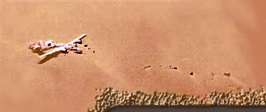
You
may have noticed how Google Earth keeps the size of the
icons and their labels consistent regardless of
the altitude you zoom to. Image overlays on the
other hand, retain their size once they are set. We
have
used
both a standard icon/label (customized to look like
LBG) and an
image overlay for the LBG wreck to illustrate the size
of the aircraft as compared to the environment that
surrounds it. The overlay is the exact
size of the
actual
LBG as it would have appeared on the Calanscio gravel
plain (110 ft wingspan x 66 ft fuselage). You have
to zoom in very close however to see the LBG overlay
begin
to resolve as it outsize's the "auto-size" behavior
of the icon/label.
Now,
to get a feeling of just how enormous
the Calanscio gravel plain actually is, zoom in close
enough to the LBG wreck so as to sense how large a human
being would be next to the wreck. Make sure and tilt
the perspective a bit so as to nearly get an more oblique
view towards the horizon.
Now
uncheck the default GE icon/label "Lady Be Good" (so
in doesn't auto-resize wider than the overlay as you
zoom
out) and
slowly zoom
back. The LBG soon becomes and nearly infinitesimal dot
before you even begin to see the sand sea on the
far
horizon.
Into this enormous and inhospitable wasteland,
almost completely devoid of vegetation, is where the
hapless crew found themselves. Considering the Liberator's
tiny size compared to the
enormous emptiness surrounding
it, it's
no wonder it took so many years for it to be spotted.
07/14/09 UPDATE: The LBG has been moved again! Sometime prior to April 28th, 2009 what remains of the Lady Be Good was removed to a "secured" location at the El Adem military Airfield 16 miles south of Tobruk. After being removed from the desert by the Libyan government in 1994, the LBG was kept in two different compounds in Tobruk (the latest from 2004-2009) and an adjacent one (from 1994-2004). During this time the LBG was relatively easy to access and view. Recently (sometime prior to April 28th, 2009) she was again moved to the location at the El Adem military airfield. This new location is reportedly not "open to the public". Photos of her Tobruk sojourn, and her slow disintegration due to years of visits by various parties, may be found in our LBG Photo Archive entitled "Tobruk Storage 1994 - 2009". As of July 11th, 2009 Google Earth's aerial photos still showed her at the Tobruk compound location.
Exactly what date she was moved to the El Adem military airfield and the details surrounding the move have not been ascertained by us as of yet. The most recent photos of her, taken at the El Adem airfield on April 28th 2009, may be viewed in the the LBG Photo Archive gallery entitled "LBG Today". These photos reveal that some parts of her remains, most notably areas of the fuselage behind the wings appear to have been further broken and damaged, as compared to relatively recent photos taken in the Tobruk compound.
Wish someone could bring you home. Till then, Rest
in Peace ol' girl.